Angkor Wat Map — How to Navigate the Complex & Park

Angkor Wat sits at the western end of the Angkor Archaeological Park, approximately 5.5 km north of Siem Reap. The main temple is entered via a 350-metre causeway from the west. The park contains dozens of temples spread across two main touring circuits — the Small Circuit (17 km) covering the most important sites, and the Grand Circuit (26 km) covering the outlying temples. A good map, a hired tuk-tuk driver, and an understanding of the circuit system are all you need to navigate the park confidently.
One of the most common anxieties for first-time Angkor Wat visitors is the sheer scale of what they are about to explore. The Angkor Archaeological Park covers approximately 400 square kilometres. The main temple alone is 1,025 metres by 800 metres at its outer enclosure. Knowing how to orient yourself — both inside the main temple and across the broader park — makes the difference between a confident, rewarding exploration and an overwhelming one.
Top Tickets
Inside Angkor Wat: How the Temple Is Laid Out
Angkor Wat is organised on three ascending levels, each enclosed by a rectangular gallery and accessible by stone staircases. The outermost level (ground level) contains the famous bas-relief galleries. The middle level is an inner courtyard. The uppermost level — the third tier — supports the five central towers and the inner sanctuary. Entry is from the west via the main causeway. The full outer enclosure measures 1,025 m × 800 m. A temple map is available at the main entrance gate.
The main western entrance and causeway:
Your tuk-tuk drops you at the western entrance to the main causeway. Walking east along the 350-metre causeway, the five towers of the temple rise progressively ahead of you. Nāga (serpent deity) balustrades line both sides. The north reflecting pool is to your left and the south reflecting pool is to your right — the north pool is the one used for the iconic sunrise reflection shot.
The main entrance gopura:
At the end of the causeway is the main entrance tower (gopura). This is the gatehouse through which you pass into the first enclosure. It is also where the ticket check occurs.
First level — the outer gallery and bas-reliefs:
Inside the main enclosure, the outer gallery is lined with the famous bas-reliefs — approximately 800 metres of carved narrative panels at eye level. Moving clockwise from the main entrance, the key panels are:
- West gallery (south half): Battle of Kurukshetra (Mahabharata)
- South gallery (west half): Army of King Suryavarman II — a procession of the Khmer king’s military
- South gallery (east half): Heaven and Hell — 32 heavens and 37 hells depicted in extraordinary detail
- East gallery (south half): Churning of the Ocean of Milk — the most celebrated bas-relief at Angkor Wat, depicting gods and demons churning the ocean to extract the elixir of immortality
- East gallery (north half): Victory of Vishnu over the Asuras
- North gallery: Battle of Lanka (Ramayana)
- West gallery (north half): Battle of the Gods and Asuras
A thorough walk of all bas-relief panels takes 45–60 minutes. Our bas-reliefs guide explains each panel in detail.
Second level:
Reached by a short staircase at the corner towers, the second level is a raised courtyard with four small ornamental pools. This level is less visited than the ground floor and first gallery — take time here for the elevated views of the surrounding jungle and the rising towers.
Third level and central sanctuary:
The uppermost level is reached by steep stone stairs — wooden stairs with handrails have been added at one access point to make the ascent safer. The platform at the top supports the five towers (the central tower and four corner towers), with the central sanctuary at the very apex. Views from the upper gallery extend over the surrounding Angkor plain. Remove shoes before entering the inner sanctuary, which houses active Buddhist shrines.
Orientation tip: The temple faces west. Entering from the causeway, you are walking east. The rising sun appears to your left (north) during a sunrise visit, which is why the north reflecting pool offers the best sunrise composition.
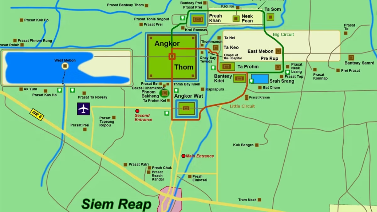
The Angkor Archaeological Park: The Two Circuits
The Angkor Archaeological Park is explored via two established touring routes, known as the Small Circuit and the Grand Circuit. Both begin and end in Siem Reap and are navigated by tuk-tuk, bicycle, or private car.
The Small Circuit (17 km)
The Small Circuit covers the most significant and most visited temples in the park. The standard order of temples on the Small Circuit:
- Angkor Wat — the main temple; allow 3–4 hours
- Phnom Bakheng — the hilltop temple between Angkor Wat and Angkor Thom; 20-minute walk up; best at sunset
- Angkor Thom South Gate — the monumental entrance to the ancient capital; driveable and walkable causeway flanked by stone gods and demons
- Bayon Temple — the temple of the giant smiling faces; inside Angkor Thom; allow 1.5–2 hours
- Baphuon — a pyramid temple inside Angkor Thom undergoing ongoing restoration; allow 45 minutes
- Phimeanakas and the Royal Enclosure — the royal palace complex; interesting ruins
- Terrace of the Elephants — a 350-metre royal viewing platform with elephant carvings; walkable in 20 minutes
- Terrace of the Leper King — a smaller terrace with intricate carvings; adjacent to the Elephants Terrace
- Ta Prohm — the famous jungle temple; allow 1.5 hours
- Banteay Kdei — a Buddhist monastery temple; 30–45 minutes
- Srah Srang — the royal bathing pool; a beautiful reflective lake; 20 minutes
For a complete route recommendation and timing strategy, see our Small Circuit vs Grand Circuit guide.
The Grand Circuit (26 km)
The Grand Circuit extends beyond Angkor Thom to the north and east, covering temples that are less visited but no less remarkable:
- Preah Khan — a sprawling Buddhist temple
- Neak Pean — an island sanctuary temple in a reservoir
- Ta Som — a small but atmospheric temple with a tree-engulfed eastern gateway
- Eastern Mebon — a pyramid temple on an artificial island
- Pre Rup — a pyramid temple excellent for sunset views
The Grand Circuit is best tackled on a second day, after completing the Small Circuit on the first.
Key Distances Inside the Park
| From | To | Distance | Approx Drive Time |
|---|---|---|---|
| Siem Reap centre | Angkor Wat | 5.5 km | 15–20 min |
| Angkor Wat | Phnom Bakheng | 1.3 km | 5 min |
| Phnom Bakheng | Angkor Thom South Gate | 1.5 km | 5 min |
| Angkor Thom | Bayon (inside Thom) | 1.5 km from south gate | 5 min |
| Bayon | Ta Prohm | 3 km | 10 min |
| Ta Prohm | Banteay Kdei | 0.5 km | 2 min |
| Siem Reap | Banteay Srei | 30 km | 40–50 min |
| Siem Reap | Beng Mealea | 40 km | 50–60 min |
Maps and Navigation Apps
Physical maps: A basic map of the Angkor Archaeological Park is available at the ticket office. More detailed maps are sold at bookshops in Siem Reap and from vendors near the temple entrances.
Digital navigation: Google Maps has reasonable coverage of the main temple roads within the park, though satellite view is the most useful mode for understanding temple layouts. Offline map apps such as Maps.me (OsmAnd) offer downloaded maps of the park that work without mobile data.
Your tuk-tuk driver: In practice, the most useful “map” is your tuk-tuk driver, who knows the park intimately and will navigate you between temples without any input from you. Let them know your priorities (sunrise at Angkor Wat, specific temples you want to see, sunset at Phnom Bakheng) and they will organise the logistics.
Frequently Asked Questions
How big is the Angkor Archaeological Park?
The Angkor Archaeological Park covers approximately 400 square kilometres. The core area containing the major temples is much smaller — the Small Circuit (covering the most important sites) is a 17 km loop. Angkor Wat itself occupies approximately 162 hectares within its outer enclosure.
Which direction does Angkor Wat face?
Angkor Wat faces west, which is unusual for Khmer temples (most face east). This westward orientation is associated with Vishnu, to whom the temple was originally dedicated, and possibly with its funerary function as a monument to King Suryavarman II.
How do I find the reflecting pool?
Walking east along the main causeway from the western entrance, the north reflecting pool is on your left and the south reflecting pool is on your right. For the iconic sunrise photograph, position yourself on the north bank of the north pool facing east — the towers will be directly ahead with their reflection below. Arrive by 5:00–5:15 AM to secure a good position.
Is there a map inside Angkor Wat?
Basic orientation signage exists at the main entrance. Free printed maps are available at the ticket office and sometimes at the main gate. For greater detail, bring a downloaded digital map or a guidebook.
Can I walk between all the temples?
Walking is practical only over very short distances inside the park — between adjacent temples like Ta Prohm and Banteay Kdei (0.5 km), or within the Angkor Thom complex. For the full Small Circuit (17 km) or Grand Circuit (26 km), a tuk-tuk or bicycle is essential.