The Khmer Empire — History Behind the Temples of Angkor

The Khmer Empire (802–1431 CE) was one of the most powerful civilisations in Southeast Asian history, ruling a territory that at its peak encompassed present-day Cambodia, Thailand, Laos, and southern Vietnam. It was governed from the Angkor region and produced Angkor Wat, Bayon, and hundreds of other temples. The empire’s political theology centred on the devaraja (god-king) concept — the idea that the king was an earthly manifestation of a Hindu or Buddhist deity. The Khmer Empire declined in the 14th–15th centuries due to a combination of Siamese military pressure, environmental degradation, and shifting trade patterns.
Walking through Angkor Wat without knowing the history of the Khmer Empire is like reading a book in a language you don’t speak: the shapes are beautiful, but the meaning is locked away. The towers represent something specific. The bas-reliefs tell particular stories. The moat and causeway are not decorative — they are cosmological statements. Understanding the empire that built all of this — its political theology, its engineering ambition, its religious evolution, and its eventual collapse — gives every stone in Angkor Wat a context that transforms the experience.
Top Tickets
Origins — Before Angkor
The political entities that preceded the Khmer Empire are conventionally grouped under the label “Funan” and “Chenla” in Chinese historical sources — terms that reflect Chinese administrative categories more than coherent political units. By the 7th and 8th centuries CE, the Cambodian region was a complex mosaic of small kingdoms speaking Old Khmer and interacting with trade networks connecting India, China, and the maritime world of Southeast Asia.
Indian cultural influence: The most consequential external influence on pre-Angkor Cambodia was Indian. The Sanskrit language, the Hindu religious system (particularly the Shaivite tradition — the worship of Shiva), and the South Indian tradition of temple construction all arrived via maritime trade routes. Brahmin priests from India served at Cambodian courts; Sanskrit inscriptions document royal genealogies in Indian literary forms. The Khmer Empire was not Indian — it was a distinctive Cambodian civilisation — but it built on Indian intellectual and religious frameworks.
Jayavarman II and the Founding of the Angkor Empire (802 CE)
The Khmer Empire is conventionally dated to 802 CE, when Jayavarman II held a ceremony on Phnom Kulen mountain in which a Brahmin priest declared him a chakravartin — a universal sovereign — and established the cult of the devaraja (god-king). This ceremony broke Cambodia’s symbolic vassalage to the Javanese kingdom (based in present-day Indonesia) and inaugurated the political theology that would define the Khmer Empire for the next 600 years.
What the devaraja concept meant: Every subsequent Khmer king was, in the political theology of the empire, an earthly manifestation of a specific Hindu deity — usually Shiva or Vishnu. His state temple was therefore simultaneously a royal palace (where the king’s divine presence resided) and a temple (where that deity was worshipped). This fusion of royal and divine identity drove the extraordinary temple-building programme of the empire — each king was obligated by the logic of the system to build a state temple expressing his divine identity.
Jayavarman II’s capital: He established his capital at Hariharalaya in the Roluos region — the site now known as the Roluos Group temples.
The Angkor Period — Major Kings and Temples
Indravarman I (reigned 877–889 CE)
The first king to build a major temple at the Roluos site: Preah Ko (879 CE) and Bakong (881 CE). He also built the first large-scale hydraulic infrastructure of the Angkor period — the Indratataka baray (reservoir) — demonstrating the engineering ambition that would characterise the empire’s approach to water management.
Yasovarman I (reigned 889–910 CE)
Moved the capital northwest to the Angkor plain proper, establishing the city of Yasodharapura and building Phnom Bakheng as its state temple. He also built a network of ashrams (hermitages) and initiated the East Baray — a massive reservoir approximately 7 km × 1.8 km that remained a key element of Angkor’s hydraulic system for centuries.
Suryavarman II (reigned c.1113–1150 CE)
The builder of Angkor Wat. Suryavarman II was a powerful military king who expanded the empire’s territory into present-day Thailand and Vietnam and built the greatest single monument in Khmer history as his state temple and mausoleum. He identified himself with Vishnu — hence Angkor Wat’s dedication — and his relationship with Shiva devotion was more complex than his predecessors. See the full Angkor Wat history for the architectural context.
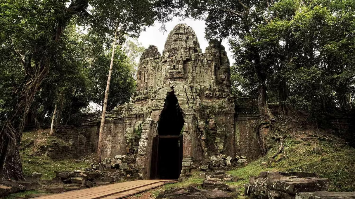
Jayavarman VII (reigned 1181–1218 CE)
The most prolific builder in Khmer history — and the king responsible for Bayon, Angkor Thom, Ta Prohm, Preah Khan, and dozens of other temples and structures. Jayavarman VII came to power after a catastrophic Cham invasion (the armies of the Cham kingdom from present-day Vietnam occupied Angkor for several years), and his rebuilding programme was both a physical reconstruction of the capital and a theological statement about the new Buddhist order.
The religious shift: Jayavarman VII was a Mahayana Buddhist — the first Khmer king to make Buddhism, rather than Hinduism, the state religion. This shift is reflected in the architecture: Bayon’s faces represent the Bodhisattva Avalokiteshvara (a Buddhist deity of compassion) rather than a Hindu god; the bas-reliefs at Bayon depict historical scenes alongside mythological ones.
The hospital network: Jayavarman VII’s inscriptions record the construction of 102 hospitals across the empire, 121 rest houses on major roads, and a network of wells and administrative infrastructure. He was, by any measure, the most ambitious builder and administrator in Khmer history.
The Hydraulic System — Engineering That Sustained the Empire
One of the most significant and debated aspects of Khmer civilisation is its hydraulic infrastructure — the network of reservoirs (barays), canals, and water management structures that sustained agriculture across the Angkor plain.
The barays: The Angkor plain is subject to extreme seasonal variation — monsoon floods in the wet season, drought in the dry season. The Khmer built a series of enormous reservoirs (the West Baray, 8 km × 2.1 km; the East Baray, 7 km × 1.8 km; and others) to store wet-season water for dry-season irrigation. The exact mechanics of how this system worked remain debated — some scholars argue it enabled intensive multi-crop rice agriculture; others argue it primarily served ritual and symbolic functions.
LIDAR discoveries: Recent LIDAR (Light Detection and Ranging) aerial surveys have revealed the full extent of the Angkor urban area — a dispersed city of approximately 1,000 square kilometres, making it one of the largest pre-industrial urban complexes ever discovered. The hydraulic network extended across this entire urban area in extraordinary detail.
The Chinese Account — Zhou Daguan (1296–1297 CE)
The most vivid historical account of Angkor at its height comes from Zhou Daguan, a Chinese envoy who spent nearly a year in the Khmer capital in 1296–1297 CE. His account (Mémoires sur les coutumes du Cambodge, translated as The Customs of Cambodia) describes the king’s daily ceremonies, the palace, the markets, the people, the food, the festivals, and the physical appearance of the city in extraordinary detail. It is the primary source for understanding what the living city of Angkor looked like — the wooden palace buildings, the canals, the daily life of its inhabitants.
Key details from Zhou Daguan: the palace was largely built of wood (gold-covered, he reports); the king appeared to his subjects daily at the palace window; the city was served by an extensive canal network; the population was mixed — Khmer, Chinese merchants, and various other groups; and Buddhist and Hindu ceremonies were practiced simultaneously.
Decline — Why the Khmer Empire Fell
The decline of the Khmer Empire in the 14th and 15th centuries is one of the most discussed questions in Southeast Asian historiography. Several factors are identified:
Siamese military pressure: The kingdom of Ayutthaya (in present-day Thailand), which emerged as a major power in the 14th century, repeatedly attacked and sacked Angkor. Angkor was captured and sacked by Ayutthayan forces in 1431, precipitating the abandonment of Angkor as the Khmer capital.
Hydraulic system failure: LIDAR surveys suggest that the Angkor hydraulic system experienced significant failures in the 14th–15th centuries — the channels silted up, major structures were not maintained, and the agricultural productivity that had sustained the urban population declined. Some scholars argue this ecological crisis was more consequential than the Siamese attacks.
Maritime trade shift: The growing importance of maritime trade (rice, pepper, spices, and Chinese manufactured goods moving through the Gulf of Thailand) shifted economic power toward coastal cities — particularly Phnom Penh and the Mekong Delta region — at the expense of the inland Angkor plain.
The capital moves south: By the mid-15th century, the Khmer court had relocated to Phnom Penh, which remains the Cambodian capital today. Angkor was not destroyed — it continued to be maintained by Buddhist monks and visited by religious pilgrims — but it ceased to be a political capital.
Angkor Today — What Survived and Why
The temples survived because they were built in stone. The palace, the houses, the markets, the hospitals — all built in wood — have vanished entirely. What remains is a remarkable concentration of stone religious architecture spanning 500 years of building tradition.
The temples survived also because they were never fully abandoned. Buddhist monks at Angkor Wat, and at dozens of other temples, maintained continuous presence throughout the centuries of political decline. Their presence protected the temples from the worst depredations and kept the knowledge of the sites alive.
Today, the Angkor Archaeological Park is managed by APSARA Authority, a Cambodian government body, in partnership with international conservation organisations. Over a million visitors per year — and $37, $62, or $72 each — contribute directly to the ongoing conservation and documentation of one of the most significant archaeological sites in the world.
Frequently Asked Questions
When did the Khmer Empire exist?
802–1431 CE, conventionally — from Jayavarman II’s founding ceremony on Phnom Kulen to the Ayutthayan sack of Angkor. Khmer civilisation itself is much older; the political entity of the “Khmer Empire” is dated to this period.
Why did the Khmer Empire fall?
A combination of Siamese military pressure (Ayutthayan attacks, particularly the sack of 1431), possible hydraulic system failure and agricultural decline, and the shift of economic power toward maritime trade routes that bypassed the inland Angkor plain.
Who were the most important Khmer kings?
Jayavarman II (founder, 802 CE), Indravarman I (first great builder), Suryavarman II (built Angkor Wat), and Jayavarman VII (most prolific builder, built Bayon and Angkor Thom) are the four kings most consequential for the Angkor temples visitors see today.
How large was the Khmer Empire?
At its peak in the 12th–13th centuries, the empire controlled approximately 1 million km² of territory — much of present-day Cambodia, Thailand, Laos, and southern Vietnam. Angkor itself (the urban area identified by LIDAR) covered approximately 1,000 km².